
Why We Invested in LGND: Unlocking Earth Data, the Next Big Modality in AI
By Andrew McMahon, General Partner at Ridgeline
When we first sat down with the founders of LGND—Nat Manning, Dan Hammer, and Bruno Sanchez-Andrade Nuño—we weren't starting from scratch. I've known Nat and Dan for years from our time in federal government when they served as Presidential Innovation Fellows. This gave me firsthand exposure to their deep expertise and commitment to a mission.
All three co-founders bring impressive credentials in geospatial data. Dan and Bruno stand out as premier minds in Earth observation: Bruno previously served as Chief Scientist at Mapbox, one of the most significant mapping companies of the past 15 years, while Dan has built mission-critical infrastructure in geospatial analytics throughout his career, including work at NASA. Nat brings deep experience as Chief Data Officer at USAID and as co-founder of multiple startups, including Kettle, an AI-native reinsurance company.
What ultimately drew us to LGND was both team expertise coupled with their compelling vision.
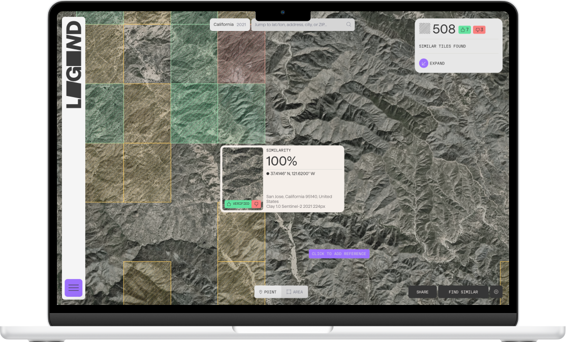
They believe—and we agree—that geospatial and Earth observation data represent a key modality in generative AI. While we've seen tremendous advances in language and image models, Earth data remains uniquely complex and historically difficult to access, analyze, and act upon. LGND is building the orchestration layer to change that.
A New Way to Interact with the Physical World
Imagine asking plain-language questions like:
"Have there been significant changes in mining operations in a certain region over the past year?" or "Is there increased runoff from farms near this river over the past decade?"
Currently, answering such questions requires specialized teams—machine learning engineers, data scientists, analysts—manually combing through satellite images and datasets to code analyses. These questions often become costly non-recurring engineering projects.
LGND transforms this process. Their orchestration layer works with Clay—and other Large-Earth Observation Models—to translate these questions into action. The system finds and analyzes relevant embeddings from massive spatiotemporal datasets, delivering precise insights in seconds.
It essentially gives Earth data the same intuitive accessibility we now have with large language models. The applications span numerous fields: finance, agriculture, national security, insurance, climate monitoring, disaster relief, infrastructure planning, and more.
Who Will Use This?
We see several key markets where LGND's platform will create significant value:
Finance & Insurance: Firms need to understand how the physical world impacts commodity pricing, real estate, underwriting, and claims. Earth data can help answer these questions more quickly and affordably than ever before.
National Security & Government: Agencies rely heavily on geospatial data, but today's workflows are expensive and slow. A model that can flag changes—such as bomb craters, pipeline leaks, or deforestation—can dramatically improve situational awareness.
Infrastructure & Energy: From understanding flood risk to estimating forest biomass or mapping mining assets, any sector where Earth is the asset can benefit.
Why This Fits Ridgeline's Thesis
Ridgeline backs companies that strengthen national resilience and economic security, including foundational infrastructure—both physical and digital.
Geospatial data is a key part of that foundation. For our commercial partners like FedEx or AutoZone, understanding where to locate distribution centers or stores depends on changes in development, climate, and terrain. Currently, they pursue these insights at significant cost and effort. LGND makes this intelligence far more accessible.
This isn't creating a new market—it's making a massive existing one dramatically easier to reach, which creates incredible opportunity.
What's Next
AI technology for earth observation is just beginning to show interest and momentum. Big tech companies are making major investments: Nvidia created "cBottle," which simulates the global climate, while Google DeepMind launched AlphaEarth Foundations, a platform that works like a virtual satellite. This follows Clay, an open-source, large earth observation model built by the founders of LGND.
Both commercial and free models are making earth data analysis available to a wider set of enterprises and consumers. This has the potential to shift geospatial analysis from a niche field to a basic technology that many will use, much like how cloud computing democratized who could build software applications.
LGND is entering an exciting product build phase. We’re eager to see how data scientists and analysts use the LGND platform to build generative-AI-style applications for Earth observation.
The future of AI isn't just about language. It's also about space, time, and place. LGND is building the infrastructure to unlock it.
Learn more about LGND at lgnd.io.